Chug Valley, Dirang, Arunachal Pradesh: A Comprehensive Guide
Chug Valley, nestled in West Kameng district near Dirang, Arunachal Pradesh, is a serene Himalayan haven. Renowned for its terraced landscapes, vibrant cosmos flowers, traditional Monpa villages, and unique cultural experiences, it offers visitors a perfect mix of natural beauty and cultural richness.
Why Visit Chug Valley?
1. Unspoiled Natural Beauty
Chug Valley is a treasure trove of breathtaking landscapes, offering visitors a serene escape into the lap of nature.
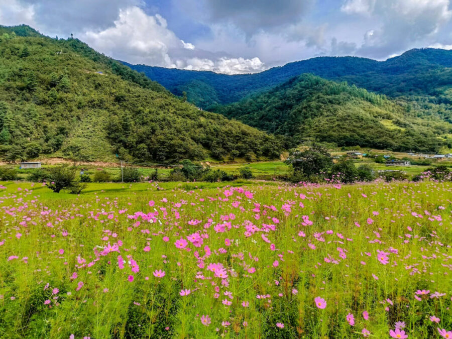
- Floral Fields: From October to mid-November, the valley transforms into a vibrant wonderland with blooming cosmos flowers. These delicate blooms sway in the mountain breeze, painting the valley in hues of pink and white, making it a perfect spot for nature photography and peaceful reflection.
- Terraced Fields: The neatly arranged red rice terraces create an awe-inspiring mosaic on the valley’s slopes. Harvest season showcases their golden hues, set against the backdrop of majestic Himalayan peaks, offering a quintessential postcard-perfect view.
- Rivers and Lakes: The Chug River, also known as Khow Odok or Mangkhow, meanders gracefully through the valley, nourishing its greenery and supporting local agriculture. In the northern highlands, glacial lakes like Dawa Photsang Motsang reflect the pristine skies and surrounding peaks, creating tranquil spots ideal for meditation and exploration.
- Dramatic Peaks and Forests: Towering mountains like Jomo Usin Buthri and Phu Phrangley frame the valley, while coniferous forests blanket the lower slopes, offering a mix of rugged adventure and serene calm.
2. Rich Cultural Heritage
Chug Valley’s rich cultural tapestry is deeply rooted in Monpa traditions, providing a unique glimpse into a harmonious way of life.
- Duhumbi Heritage Fair: This vibrant annual fair celebrates Monpa traditions with cultural performances, local crafts, and authentic cuisine. Folk dances, music, and storytelling sessions bring the valley’s legends to life. The fair also serves as a marketplace for artisans to display handwoven textiles, jewelry, and pottery, making it an immersive experience for visitors.
- Living Museum: A historic Monpa ancestral home, lovingly restored by Leike Chomu, showcases traditional life. Inside, visitors find ancient utensils, bamboo baskets, and a central fireplace that once served as the heart of communal living. The attic, once used for storing grains, demonstrates the practicality and sustainability of Monpa architecture.
- Authentic Cuisine: The valley’s culinary offerings are a reflection of its culture. At places like Damu’s Heritage Dine, visitors can savor dishes like momos, thukpa, millet porridge, and fermented foods, prepared using organic, locally sourced ingredients. Culinary workshops also allow guests to learn the secrets of Monpa cooking.
3. Wildlife and Conservation
Chug Valley is not only a haven for humans but also a sanctuary for diverse wildlife, making it a must-visit for eco-conscious travelers.
- Biodiversity: Designated as a community-conserved area, the valley is home to rare species like the red panda and a variety of Himalayan birds. The forests are alive with the sounds of nature, including chirping warblers and fluttering butterflies. Rhododendrons, blue pines, and junipers dominate the landscape, adding bursts of color and texture to the scenery.
- Ecological Importance: Beyond their visual appeal, the cosmos flowers play a vital ecological role. They attract pollinators such as bees and butterflies, essential for maintaining the balance of the valley’s ecosystem. Additionally, these flowers act as natural pest repellents, protecting staple crops like red rice and millet from harmful insects.
- Wildlife Habitat: The forests and glacial regions of Chug Valley serve as critical habitats for a variety of species, including Himalayan musk deer, pheasants, and snow leopards in higher altitudes. Visitors have the rare chance to spot some of these creatures during guided treks.
4. Spiritual Serenity
Chug Valley offers a tranquil retreat for those seeking peace and introspection.
- Monasteries and Gompas: The valley is dotted with small gompas (Buddhist temples) that serve as places of worship and meditation. The serene surroundings and the gentle hum of prayers create a calming atmosphere for spiritual seekers.
- Traditional Rituals: Engage with local monks and villagers to witness or participate in traditional rituals that reflect a deep connection with nature and spirituality.
5. Unique Adventure Opportunities
For the adventurous, Chug Valley offers a range of activities to quench the thirst for exploration.
- Trekking and Hiking: Trails to peaks like Phu Tsorgan and Phu Dumba offer breathtaking views of the valley and beyond. The trek to the Dawa Photsang Motsang Lakes is particularly rewarding for its serene beauty and untouched surroundings.
- Nature Walks: Guided nature walks through the valley’s forests allow visitors to learn about local flora and fauna while enjoying the crisp mountain air.
Chug Valley seamlessly blends natural beauty, rich heritage, and ecological significance, making it a destination that appeals to travelers of all kinds. Whether you seek adventure, culture, or peace, Chug Valley has something unique to offer, ensuring it remains etched in your memory long after your visit.
Here’s a concise description of the landmarks in and around Chug Valley based on the provided data:
Landmarks in and Around Chug Valley
| Landmark |
GPS Coordinates |
Altitude (masl) |
Description |
| Chug Valley |
|
|
|
| Confluence Gongri-Chug River |
27°23’37.18”N 92°12’16.49”E |
1,643 |
Meeting point of the Gongri and Chug rivers, a scenic and significant site in the valley. |
| Shartong Gonpa |
27°23’40.36”N 92°12’07.75”E |
1,646 |
A monastery showcasing Monpa spirituality and architecture. |
| Gonpa Nyamgoteng |
27°24’10.13”N 92°11’12.48”E |
2,313 |
Another significant monastery with a serene ambiance. |
| Old Footbridge |
27°24’09.27”N 92°12’18.94”E |
1,658 |
Traditional river crossing offering picturesque views. |
| Kakaling Gate |
27°24’13.50”N 92°12’18.92”E |
1,664 |
Historical entrance to the valley. |
| Shader Hamlet |
27°24’49.11”N 92°12’19.11”E |
1,727 |
A quaint hamlet reflecting traditional Monpa life. |
| New Footbridge |
27°24’44.88”N 92°12’29.09”E |
1,675 |
A modern crossing over the river connecting key locations. |
| Sangngakchöling Gonpa |
27°25’06.62”N 92°12’19.19”E |
1,787 |
Monastery with religious significance and peaceful surroundings. |
| Kapang Hamlet |
27°25’05.89”N 92°12’25.80”E |
1,711 |
A settlement with traditional Monpa houses. |
| Motorable Bridge |
27°25’14.84”N 92°12’31.42”E |
1,699 |
Facilitates vehicular movement within the valley. |
| Malekama Village |
27°25’16.39”N 92°12’19.72”E |
1,750 |
A vibrant village showcasing Monpa culture. |
| Duhum Village |
27°25’29.71”N 92°12’22.18”E |
1,752 |
Known for its rich cultural heritage and community spirit. |
| Lekuring Hamlet |
27°25’46.32”N 92°12’26.28”E |
1,751 |
A tranquil hamlet with stunning views and traditional life. |
| Samtu Village |
27°26’18.32”N 92°12’24.20”E |
1,828 |
A high-altitude village offering breathtaking views of the valley. |
| Jomo Usin Buthri |
27°34’29.94”N 92°11’26.02”E |
4,848 |
One of the tallest peaks in the valley with dramatic vistas. |
| Phu Dumba |
27°33’25.75”N 92°12’32.25”E |
4,573 |
A peak known for its challenging treks and scenic beauty. |
| Dawa Photsang Motsang |
27°33’58.90”N 92°12’55.31”E |
4,358 |
Stunning glacial lakes in the northern part of the valley. |
| Phu Phrangley |
27°34’00.26”N 92°13’26.57”E |
4,780 |
A prominent peak offering panoramic views of the valley. |
| Phu Tsorgan |
27°32’29.71”N 92°13’53.80”E |
4,576 |
Another high-altitude peak, ideal for trekking enthusiasts. |
| Laphek Village |
27°25’40.95”N 92°13’16.21”E |
2,125 |
Traditional village showcasing Monpa lifestyle. |
| Bumpa |
27°25’25.80”N 92°12’34.70”E |
1,707 |
A scenic hamlet amidst terraced fields. |
| Chuskhor |
27°25’14.54”N 92°12’40.88”E |
1,721 |
Known for its traditional water mill and agricultural practices. |
| Mani Dogorba |
27°25’08.80”N 92°12’41.34”E |
1,708 |
A hamlet with significant cultural and agricultural contributions. |
| Tsangpa Thup |
27°24’54.57”N 92°12’41.64”E |
1,720 |
Picturesque views and historical significance. |
| Pharchu (Abandoned) |
27°24’35.56”N 92°12’40.77”E |
1,733 |
An abandoned village reflecting historical habitation patterns. |
| Donglok (Abandoned) |
27°24’30.84”N 92°12’48.99”E |
1,807 |
A deserted village with traces of historical Monpa life. |
| Jagarbasti (Gov. School) |
27°24’30.48”N 92°12’31.74”E |
1,682 |
Location of a government school serving the community. |
| Nishithang |
27°24’17.12”N 92°12’27.98”E |
1,696 |
A settlement surrounded by lush greenery. |
| Namsir (Abandoned) |
27°24’15.31”N 92°12’42.41”E |
1,828 |
Historical village with abandoned structures. |
In the Surrounding Area of Chug Valley
| Landmark |
GPS Coordinates |
Altitude (masl) |
Description |
| Lungthang Village |
27°35’41.69”N 92°11’09.11”E |
4,154 |
High-altitude Brokpa settlement with alpine landscapes. |
| Sangthi Village |
27°24’17.93”N 92°16’37.13”E |
1,587 |
Known for its agricultural richness and serene ambiance. |
| Dirang Dzong |
27°20’37.09”N 92°16’23.49”E |
1,529 |
Historical fort showcasing local architecture and history. |
| Yewang Village |
27°21’14.69”N 92°14’03.63”E |
1,741 |
Features traditional Monpa homes and terraced farming. |
| Lish Thup Village |
27°22’41.45”N 92°13’23.64”E |
1,778 |
A charming village with cultural significance. |
| Lish Gonpatse Village |
27°22’39.13”N 92°12’46.29”E |
1,978 |
Quaint village with scenic landscapes. |
| Khamkhar Village |
27°23’07.62”N 92°12’03.49”E |
1,748 |
Offers cultural and agricultural experiences. |
| Lubrang Village |
27°21’54.47”N 92°10’47.22”E |
2,835 |
High-altitude village with lush surroundings. |
| Nyukmadung Village |
27°25’02.88”N 92°07’54.54”E |
2,347 |
Known for its pristine environment and unique location. |
| Senge Village |
27°27’04.84”N 92°07’04.15”E |
2,903 |
Gateway to higher Himalayan terrains, offering panoramic views. |
Source: Duhumbi Scenes: Chug Valley Landscapes
This table provides a comprehensive reference to navigate and explore Chug Valley and its surroundings. Let me know if you’d like to include more details!
How to Reach Chug Valley, Arunachal Pradesh
Located in the serene West Kameng district near Dirang, Chug Valley is accessible via a combination of road, rail, and air travel. Here’s a detailed guide to reaching this hidden Himalayan gem:
1. By Air
- Nearest Airport: Tezpur Airport (Salonibari Airport)
- Distance: Approximately 200 km from Dirang.
- Connectivity: Limited flights to and from Guwahati, Kolkata, and other major cities.
- Alternate Airport: Lokpriya Gopinath Bordoloi International Airport, Guwahati
- Distance: Around 350 km from Dirang.
- Connectivity: Frequent flights from major Indian cities.
- Suitable for international travelers as well.
- From the airport, hire a cab or take public transport to reach Dirang and then continue to Chug Valley.
2. By Train
- Nearest Railway Station: Rangapara North Railway Station (Assam)
- Distance: Approximately 210 km from Dirang.
- Connectivity: Well-connected to Guwahati and other northeastern towns.
- Alternate Railway Station: Guwahati Railway Station
- Distance: Around 350 km from Dirang.
- Ideal for travelers arriving from distant cities.
- After arriving at the railway station, you can take a taxi or shared vehicle to reach Dirang and Chug Valley.
3. By Road
- From Guwahati:
- Distance: Around 350 km to Dirang.
- Route: Guwahati → Tezpur → Bomdila → Dirang → Chug Valley.
- Travel Time: Approximately 8–10 hours by car or bus.
- From Tezpur:
- Distance: Around 200 km.
- Route: Tezpur → Bomdila → Dirang → Chug Valley.
- Travel Time: 6–8 hours by car.
- From Tawang:
- Distance: Around 160 km.
- Route: Tawang → Bomdila → Dirang → Chug Valley.
- Travel Time: 5–6 hours by road.
- Public Transport:
- Regular buses and shared taxis operate between Guwahati, Tezpur, and Dirang. From Dirang, hire a local cab to reach Chug Valley.
4. By Local Transport
- From Dirang:
- Chug Valley is approximately 43 km from Dirang.
- Local taxis or private vehicles are the best options for this journey.
- Travel Time: 1–2 hours depending on road conditions.
Important Travel Tips
- Permits:
- Indian tourists need an Inner Line Permit (ILP) to enter Arunachal Pradesh.
- International travelers require a Protected Area Permit (PAP).
- These can be obtained online or at designated offices in Guwahati or Tezpur.
- Road Conditions:
- The roads leading to Chug Valley can be winding and steep. A sturdy vehicle and experienced driver are recommended.
- Best Time to Travel:
- March–May: Ideal for trekking and exploring the valley in mild weather.
- October–November: Enjoy the cosmos bloom and cultural festivals.
- Avoid monsoon months (June–August) due to landslides and difficult road conditions.
- Local Guides:
- Hiring local guides is recommended to navigate the terrain and enhance your exploration experience.
Chug Valley’s journey is as beautiful as the destination itself, offering breathtaking landscapes and glimpses of traditional life at every turn. Whether you’re an adventurer or a cultural enthusiast, the route to Chug Valley is an adventure worth undertaking.