
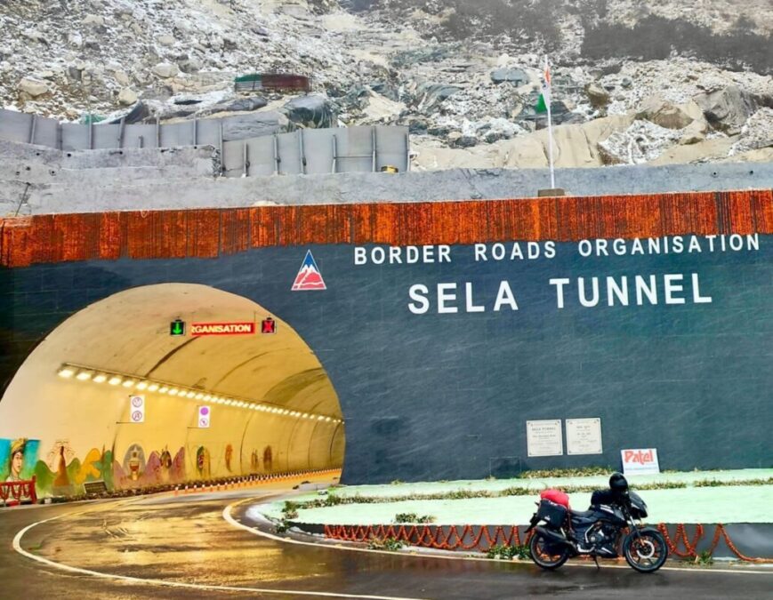
The change is most noticeable in winter. Instead of making every through-journey climb to the approximately 4,200-metre Sela Pass, traffic can now pass beneath the mountain through the tunnel alignment at roughly 3,000 metres (9,800 feet). The pass itself, however, remains an important part of the landscape and a separate sightseeing stop.
Where Is Sela Tunnel?
Sela Tunnel is situated in the Sela–Charbela mountain region on the Tezpur–Bomdila–Dirang–Tawang corridor of NH-13. It passes beneath the Sela mountain system between the Dirang and Tawang sides of the highway.
There is a useful distinction between the figures often quoted for the project. Government descriptions place the project at about 13,000 feet, while the tunnel itself is generally described at around 3,000 metres. Sela Pass rises much higher, at approximately 4,200 metres (13,800 feet).
Sela Tunnel at a Glance
| Feature | Details |
|---|---|
| Location | Sela–Charbela region, Arunachal Pradesh |
| Highway | Balipara–Chariduar–Tawang Road / NH-13 |
| Project | Sela Tunnel Project, Project Vartak |
| Agency | Border Roads Organisation (BRO) |
| Main tunnel | Approximately 1,555 metres |
| Escape tunnel | Approximately 980 metres |
| Approach roads | Approximately 8.8 km in the original project configuration |
| Project elevation | About 13,000 feet |
| Tunnel alignment | Approximately 3,000 metres / 9,800 feet |
| Sela Pass | Approximately 4,200 metres / 13,800 feet |
| Construction method | New Austrian Tunnelling Method (NATM) |
| Cost | Approximately ₹825 crore |
| Dedicated to nation | 9 March 2024 |
The principal structure is a 1,555-metre bi-lane road tunnel accompanied by a separate 980-metre escape tunnel. During construction, BRO described it as the world’s longest bi-lane road tunnel at an altitude above 13,000 feet. That specific description is more accurate than the commonly repeated phrase “world’s highest tunnel”.
What Is the Journey Through Sela Tunnel Like?
Approaching from Dirang, the road gradually climbs into the Sela mountain country before entering the tunnel. Inside, the character of the journey changes completely: there are no lakes, viewpoints or open mountain panoramas, only the illuminated road corridor passing beneath the mountain. A few minutes later the vehicle emerges on the Tawang side and the landscape opens again.
That is the essential difference between the tunnel and the old crossing. The tunnel is a piece of road infrastructure experienced from inside a vehicle; the surrounding Sela country is where the scenery is experienced.
Sela Tunnel and Sela Pass: What Is Common and What Is Different?
Both routes belong to the same Dirang–Tawang journey, and the wider road trip can include the same major attractions towards Tawang. The difference occurs at the Sela mountain section.
| Place / Experience | Through Sela Tunnel | Via Sela Pass |
|---|---|---|
| Sela Tunnel | Yes | No |
| Sela Pass | No | Yes |
| Sela Lake | No | Yes |
| Open snow-covered landscape | Limited | Yes |
| High-altitude viewpoints | No | Yes |
| Dirang–Tawang mountain scenery | Yes | Yes |
| Jaswant Garh | Yes | Yes |
| Jung / Nuranang Falls | Yes | Yes |
| Tawang | Yes | Yes |
Sela Pass and Sela Lake are not part of the tunnel journey. They lie on the old high-altitude route and should be specifically included in the itinerary if they are a priority. Conversely, using the pass does not mean missing the rest of the Tawang road experience: the wider route, Jaswant Garh, Jung/Nuranang Falls and Tawang remain part of the same journey.
When conditions allow, seeing the pass on one journey and using the tunnel on another gives the clearest impression of how the road has changed. The old route shows the mountain; the new route shows how the mountain has been engineered through.
Why Was Sela Tunnel Built?
The problem was not simply distance. The old road climbed into an exposed section of the Eastern Himalaya where snow, ice, strong winds and poor visibility could interrupt movement. By taking the principal crossing below the summit level, the tunnel removes the most vulnerable part of that ascent from the through-route.
It does not make the entire Tezpur–Tawang highway immune to winter weather. Roads approaching and leaving the tunnel can still be affected by snowfall, landslides, rockfall, freezing conditions, maintenance and temporary restrictions. What changes is the reliability of the critical Sela crossing itself.
The Engineering of Sela Tunnel
The tunnel was constructed using the New Austrian Tunnelling Method (NATM), in which excavation and support are adapted to the geological conditions encountered underground. That flexibility matters in the Himalaya, where rock strength, fractures and groundwater can change considerably along a single alignment.
The surrounding Western Arunachal Himalaya is equally complex geologically. Research from the Tawang and West Kameng region records migmatitic gneisses of the Sela Group, Tertiary leucogranites, metasedimentary rocks of the Lumla and Dirang formations and granite gneiss of the Bomdila Group. The tunnel therefore cuts through a mountain system with a complicated geological history rather than a uniform rock mass.
A Landscape Shaped by Glaciers
The Sela landscape is also a record of much older climatic change. Geological Survey of India research on the Late Quaternary glacial history around Sela Pass examines glacial landforms, glacier recession and palaeo-permafrost, helping explain how the high mountain terrain visible today was formed.
That history is easy to overlook from the road. The snow seen around Sela is part of the present climate; the broad valleys, ridges and deposits across the landscape carry evidence of processes that operated over thousands of years.
Sela Tunnel in Winter
Winter is when the tunnel’s practical value is most obvious. Sela Pass can experience heavy snow and freezing conditions, while the tunnel provides a protected alternative at a lower elevation. This is particularly important for maintaining movement towards Tawang during periods when the exposed mountain road becomes difficult.
For visitors, however, the distinction between accessibility and guaranteed access is important. The tunnel improves the route, but it cannot control weather on the rest of the highway. A winter Tawang journey should therefore still allow for changing road conditions and local travel instructions.
Dirang, Sela and the Road to Tawang
Dirang is one of the most useful bases before heading towards Sela and Tawang. From the valley, the road climbs steadily through forests and steep mountain terrain, eventually reaching the high Sela country before descending towards the Tawang side.
The scenery changes remarkably along the way: lower valleys and forests gradually give way to alpine slopes and the stark, open mountain environment around Sela. Beyond the Sela section, the road continues towards attractions such as Jaswant Garh and Jung/Nuranang Falls before reaching Tawang.
Strategic Importance
The Tawang road is important not only because it carries tourists and local traffic but because Tawang lies close to India’s international boundary with China. A dependable road corridor is consequently significant for defence logistics, civilian movement and regional development.
Sela Tunnel strengthens that corridor by reducing dependence on the exposed pass crossing, making it one of the most consequential pieces of road infrastructure on the route to Tawang.
Frequently Asked Questions
What is Sela Tunnel?
Sela Tunnel is a high-altitude road tunnel on the Tezpur–Tawang highway in Arunachal Pradesh, built to bypass the exposed Sela Pass and improve connectivity to Tawang.
When was Sela Tunnel dedicated to the nation?
The tunnel was dedicated to the nation by Prime Minister Narendra Modi on 9 March 2024.
How long is Sela Tunnel?
The main bi-lane tunnel is approximately 1,555 metres long, with a separate approximately 980-metre escape tunnel.
How high is Sela Tunnel?
The Government describes the overall project at about 13,000 feet, while the tunnel alignment is approximately 3,000 metres or 9,800 feet.
How high is Sela Pass?
Sela Pass is approximately 4,200 metres or 13,800 feet above sea level.
Can I see Sela Lake when travelling through Sela Tunnel?
No. Sela Lake is on the high-altitude pass route and is not visible from inside the tunnel.
Does Sela Tunnel replace Sela Pass?
No. It provides the modern through-route, while Sela Pass remains a separate scenic and geographical landmark.
Can tourists travel through Sela Tunnel?
Yes. Tourists travelling by road between Dirang and Tawang use the tunnel when the route is open for civilian movement.
Is Sela Tunnel open in winter?
The tunnel was designed to provide an all-weather alternative to the exposed pass crossing, although winter weather can still affect other sections of the highway.
Is Sela Tunnel the world’s highest tunnel?
It is more accurate to use BRO’s specific description of it as the world’s longest bi-lane road tunnel at an altitude above 13,000 feet during its construction rather than simply calling it the world’s highest tunnel.
What is NATM in Sela Tunnel?
NATM, or New Austrian Tunnelling Method, is a tunnelling technique in which excavation and structural support are adapted to the geological conditions encountered underground.
Plan Your Tawang Journey
Sela Tunnel has made the road to Tawang more resilient, but it has not diminished the appeal of the landscape above it. A complete journey can combine Dirang, Sela Pass, Sela Lake, the Sela Tunnel corridor and Tawang, depending on the route permitted on the day and the prevailing mountain conditions.
Plan your Arunachal Pradesh journey with SetMyTrip and experience the Tezpur–Dirang–Sela–Tawang road with current seasonal travel information.
